| |
https://nguyentrips2010.tripod.com/
PhillipNguyen@gmail.com
pw: pn np TPL
Last update : Aug 23 by Phillip
New!
- Since this is long trip
I have many thing to pack, I will take care all tent and blanket
parts, 4 of you will share ONLY in the two passenger rows (even your
air mattress (if you want) have to be placed in the two rows), in
these two row you have to let us put 2 camera bags + big see thru
food storage :( Please cooperate and pack your self effectively. Be
ready to share small space in 15 hrs then you be granted for Grand
Canyon :)
- -
- I already have 2 walkie talkie
, if we have one more walkie talkie (operated by AA bat, I bring
many AA bat) is good for our group because cell phone will NOT work
in National Parks
Kim Ben et All,
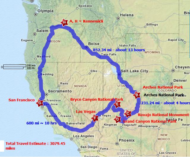
Our planning trips for Grand Canyon
and more is in
https://nguyentrips2010.tripod.com/
Please look at schedule and tell me if
you have any suggestions, we will make 3100+ miles in
16 days, in this
16
days we will spend 6
days in hotels (for detail hotel days see date Aug 26,27, Sept 4,5,6,7), 8
days in camp sites and 2 days on the road, we will start on noon
Aug 25 and be back in Kennewick on
Sept 9,10 . Since our small van will be fully packed with 6 persons,
please do NOT ask me any additional guess (unless you have enough people
for another car)
Dad will pay for 6 of us but you will
pay for your own extra expense such as using slot machine in Las Vegas.
Small thing I asked you guys that playing small money on slot machine
for fun will be OK to me BUT games like poker, black jack and the
likes is NO.
Please take time to read, keep in mind
changing hotel/camping reservation and date are very costly. If you have
time please make quick review if the date I book for hotels and camping
sites correctly
GUYS: Please go to
http://www.nps.gov/grca/index.htm
apply for Special Hiking Permit - Thanks
Dad |
| Aug 26, 27 2010 |
Drive around the Arches National Park for sight seeing and
picture + Make campsite at slot 022, DEVILS GARDEN CAMPGROUND.
Check in hotel for 2 night Aug 26,27 and check out on Aug 28 early
morning (We do BOTH hotel & campsites)
Note All 6 day hotels booked by
http://www.expedia.com/
under pn-gm pw template xxeptpl
Silver
Sage Inn
840 S Main St
Moab, UT 84532
United States of America
|
|
|
The reservation is
confirmed by Silver Sage Inn. Your reservation
is guaranteed with your credit card. If your plans
change, you must cancel or change your hotel
reservation in accordance with the hotel
cancellation policy to avoid a no-show charge.
Please refer to the cancellation and change policies
listed below |
| |
| Expedia
itinerary number: 133418674700
|
| Hotel
confirmation number:
128246265
|
|
Main contact:
Phillip Nguyen
E-mail: phillipnguyen@gmail.com
|
|
| |
|
|
|
|
Traveler and cost summary
|
Room/unit rate |
Reserved for:
Phillip Nguyen |
Hotel: 4 adults |
Best Available Rate Standard Guestroom 2
Double Beds Nonsmokingfree Wifi Refrigerator
Microwave Coffee Maker
|
$89.95 per night |
|
Taxes may or may not be included in total
|
|
Room cost |
$179.90 |
|
|
|
|
 Thu Aug-26-2010 (2 nights)
|
|
|
Silver Sage Inn |
|
|
| |
840 S
Main St
Moab, UT 84532
United States of America
|
|
Check in: Thu
Aug-26-2010
Check out: Sat
Aug-28-2010
|
|
|
|
For
reservation questions and other information
contact the hotel:
Tel: 1 (435) 259-4420 Fax: 1 (435)
259-2347 |
|
|
|
|
|
| Unless
specified otherwise, rates are quoted in
US dollars. |
| Your
stay is longer than 1 night. Your room/unit
rate might not be the same for all nights.
Please check Rate information below to
verify nightly rate details. |
| The
price shown above DOES NOT include any
applicable hotel service fees, charges for
optional incidentals (such as minibar snacks
or telephone calls), or regulatory
surcharges. The lodging will assess these
fees, charges, and surcharges upon
check-out. |
| If a
late check in is planned, contact this
lodging directly for their late check-in
policy. |
|
- Reservation #: 2-14091730
- Arrival Date: Thu Aug 26 2010
- Check-in: 12:00 pm
- State:
- Site, Loop: 022, DEVILS GARDEN CAMPGROUND
(UT)
|
- Reservation Type: Overnight
- Departure Date: Sat Aug 28 2010
- Check-out: 10:00 am
- Facility: DEVILS GARDEN CAMPGROUND (UT),
Arches National Park, UT
|
Many trails, complete AT LEAST one below trail:
Map:
http://www.nps.gov/arch/planyourvisit/upload/archmap.pdf
Devils Garden Primitive Loop (challenge loop)
Starting Point: Devils Garden Trailhead parking area
Length: 7.2 mi/11.5 km round-trip, including all points of interest
Time: 3 to 5 hours
Longest of the maintained trails in the park, the Devils Garden Trail
leads to eight awe-inspiring arches. Expect narrow ledges with rocky
surface hiking and scrambling on slickrock. Not recommended when rock is
wet or snowy. Trail guide available at trailhead.
Double O Arch (easy loop)
Starting Point: Devils Garden Trailhead parking area
Length: 4 miles (6.4 km) round trip
Time: 2 to 3 hours
Beyond Landscape Arch, the trail becomes more challenging as it climbs
over sandstone slabs; footing is rocky; there are narrow ledges with
exposure to heights. Spur trails lead to Partition and Navajo Arches.
Dark Angel is one-half mile (0.8 km) farther. Trail guide available at
trailhead.
FMI:
http://www.nps.gov/arch/planyourvisit/longtrails.htm
|
Early Morning PHOTO |
Late Afternoon PHOTO |
| Moab Fault |
Park Avenue |
| The Three Gossips |
Courthouse Towers |
| Sheep Rock |
Petrified Dunes |
| The Great Wall |
Balanced Rock |
| Turret Arch |
The Garden of Eden |
| The Spectacles |
North and South
Windows |
| Double Arch |
Delicate Arch |
| Cache Valley |
Fiery Furnace |
| Wolfe Ranch |
Skyline Arch |
| Landscape Arch |
Fins in Devils Garden |
| Double O Arch |
Tower Arch |
Double Arch
 Delicate
Arch Delicate
Arch
Mules Ears and Courthouse Towers
|
| Aug 28, 2010 |
Leave Arches National Park in morning of Aug 28 and try to
complete 240 miles (4 hr) to NAVAJO
http://www.nps.gov/nava/index.htm
Navajo National Monument is located at the end of State Highway 564 off
of US Highway 160 Where? run Google Map
http://maps.google.com/maps?hl=en&tab=wl and copy/paste: Navajo
National Monument, Shonto, Arizona 86054
Why NAVAJO ? because we want to see:
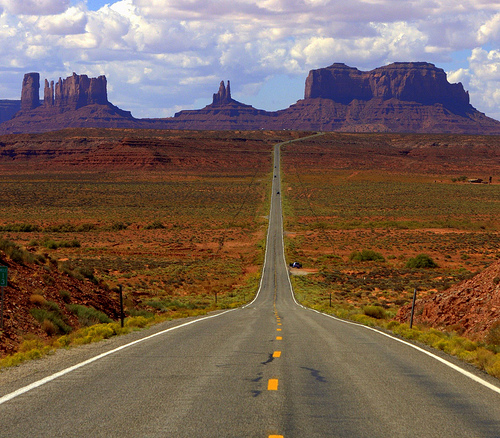
View of Monument Valley in Utah, looking south on highway 163 from 13
miles north of the
Arizona/Utah State line.
Monument Valley, Navajo Indian Reservation, Utah, FWY 163 2 miles
south of border line has intersection road called Monument Valley Rd
N� l� Monument Valley, N� nằm tr�n FWY 163 v� c� đường cắt ngang t�n
l� Monument Valley Rd.
http://maps.google.com/maps?f=q&source=s_q&hl=en&geocode=&q=Monument+Valley&sll=37.0625,-95.677068&sspn=47.215051,79.013672&ie=UTF8&hq=&hnear=Oljato-Monument+Valley,+Navajo,+Arizona&ll=36.978832,-110.12043&spn=0.093662,0.219727&t=h&z=13&iwloc=A
http://www.utah.explorefourcorners.com/monument_valley.html
If you have ever watched any Western movie, you may have likely
already seen the infamous area of Monument Valley. Towering rock
formations rising up to 1,000 feet tall, make this desert scene a
favorite among tourists. Monument Valley is located along the
Utah/Arizona border on the Navajo Indian Reservation
Entrance Fees
General Admission: $5
Ages 9 and under are free
For travelers looking for contemporary
amenities in their camping facilities should
stay at Goulding's
Campground. Situated at the
Arizona-Utah border, this campground has
full RV hookups, tent sites, wireless
internet, heated pool, laundromat,
playground, cable, grocery store. It is open
year round, though some amenities are not
available in the off-season. In addition to
the RV and tent sites, there are camping
cabins that include linens, TV, kitchen, and
bathroom. Please visit Goulding's Campground
at http://www.gouldings.com/english/campground.htm
or call (435) 727-3231.
Near the Monument Valley Visitor's Center
sits the Mitten View
Campground. This camping facility is
convenient to Valley Drive and is operated
by the Navajo Nation. There are 99 sites
(though there are no hookups), flush
toilets, drinking water, and coin operated
showers. Campsites all have tables, BBQ
grills, ramadas, and trash bins. For more
info, please call (435)727-5870.
Mitten View Campground (some said
it closed will check, use Goulding's
Campground.)
Fees: $10 (1 - 6 people), $20 for (6 - 13 people), $2 for each
additional person. Winter rates are half price. *Prices are subject to
change at anytime without prior notice.
FMI:
http://canyonlandsnationalpark.explorefourcorners.com/
http://www.travellerspoint.com/guide/Monument_Valley/
Canyon View Campground - Just
for info we will not spend night time here in this trip
Open
April 1 through September 30
Phone
928/672-2700
This simple campground is a tenth of a mile away from the visitor center
on an unpaved road. It is free and quiet, and has fine canyon views on
both sides. There are 16 sites, three of which are good for group
camping. These group sites can be reserved by calling (928)672-2700.
There are composting toilets, charcoal grills, and no water; water is
available at the other campground. People enjoy this campground for its
silence and spectacular night skies.
Sunset View Campground Just for info
we will not spend night time here in this trip
Open All Year
This free campground with paved roads is close to the visitor center,
has 31 small sites with picnic tables, charcoal grills, and parking
spaces. There are restrooms and running water. No hookups are available;
RV's are limited to 28 feet or less. The campground is first-come,
first-served. In the winter, campers should be prepared for cold
temperatures and snow. The terrain is sandstone and pinyon-juniper
forest; the campground is private and restful.
Make sure we do enough Monument Valley, Navajo Indian Reservation,
Utah. Leave Navajo (late OK) to the South Rim Grand Canyon (SRGC), 250
miles (3 hrs), the first night at SRGC,
http://www.nps.gov/grca/index.htm ,
We Camp at Mather Campground
http://www.nps.gov/grca/planyourvisit/cg-sr.htm
Open year-round. Operated by the National Park Service
and located in Grand Canyon Village, this campground offers tent and RV
camping. Accessible campsites and restrooms are available. Pets are
allowed, but must be leashed at all times, and may not be left
unattended. Wood and charcoal fires permitted in provided campsite
grills only. No gathering of down wood, wood may be purchased at the
general store. Laundry and showers located near
the campground for a fee.
- Reservation #: 2-13381677
- Arrival Date: Sat Aug 28 2010
- Check-in: 12:00 pm
- State: Arizona
- Site, Loop: 073, 40-51,65-103,106-120,173-184
|
- Reservation Type: Overnight
- Departure Date: Thu Sep 02 2010
- Check-out: 11:00 am
- Facility: MATHER CAMPGROUND (AZ), Grand Canyon National
Park, AZ
Facility Details
Map Driving Route
- Site Type: TENT ONLY NONELECTRIC
|
Our Reservation lot
# 073 under PhillipNguyen for
5 night (Actually we will stay here for 4 nights, 3 days, One EXTRA
night, just for in case,)
Aug 28, 2010 is the first night we are at
the South Rim Grand Canyon (SRGC)
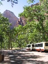
http://www.nps.gov/grca/planyourvisit/shuttle-buses.htm#CP_JUMP_157609
South Rim Shuttle Bus Routes 2010:
Jump to:
The
Hiker Express Shuttle (through Sep. 12, 2010)Tusayan
Park & Ride
This Summer, free shuttle buses are operating on four
routes.
- The routes interconnect, but do
not overlap.
- No tickets are required, and bus
stops are clearly marked throughout the park by signs.
- Buses are white with a green
stripe.
- The buses display the route name
on the front and on the boarding side.
- All buses are equipped with
bicycle racks. Bicycle one way and ride the shuttle the
other.
- Pets are not permitted on buses.
- Service may be suspended during
inclement weather.
You may download the South Rim Transit Map. It shows Grand
Canyon Village shuttle bus routes, stops, operating
times, points of interest and parking lots.
Download Summer
2010 S. Rim Transit Map (450 kb PDF File)

|
|
How do I use the free shuttle buses ? |
|
Park your vehicle in one of the parking areas,
proceed to the nearest bus stop, and board the next
bus. It is that simple. The buses come by every
15�30 minutes. You are free to get on and off at any
stop. The routes are designed so you can ride to a
stop, enjoy the view, shop at a gift store, or walk
along the rim and then hop on a later shuttle. |
|

|
|
The new shuttle bus stop and transit center is east
of the visitor center and south of parking lot 2.
The transit center can accommodate up to 4 shuttle
buses at one time. The Village (Blue Route), the
Kaibab Trailhead (Green Route) and the Tusayan
(Purple Route) buses stop here. To get to the scenic
Hermit Road (Red Route), you take the Village (Blue
Route) bus from here - then transfer to the Hermit
(Red Route) at the Hermit Road Interchange. Your
driver will announce all stops along the way. |
|
Village Route (BLUE)
60 minutes round trip

Village Route bus stop below the El Tovar
Hotel.
Buses provide transportation
between:
Visitor Center, Bookstore and Plaza,
Yavapai Point Museum of Geology
Market Plaza:
General Store, Bank, Post Office
Historic District:
lodges, restaurants, gift shops
campgrounds, parking lots,
ranger programs,
and other facilities in the Village area.
This is not a scenic route, but
rim views are available a short walk from many stops.

Boarding Village Route bus at the Transit
Center.
60 Minutes Round-trip
(without getting off the bus)
June, July, and August buses run every:
30 minutes 4:15 a.m. to 6:30 a.m.
15 minutes 6:30 a.m. to 9:00 p.m.
30 minutes 9:00 p.m. to 11:00 p.m.
September buses run every:
30 minutes 5:15 a.m. to 6:30 a.m.
15 minutes 6:30 a.m. to 7:30 p.m.
30 minutes 7:30 p.m. to 10:00 p.m.

BLUE ROUTE BUS
Insider's Look
Webisode 045: Jun 4, 2010
Interviews with drivers of the
VILLAGE - or BLUE shuttle route.
If you are coming to the park this summer you could end
up riding our shuttles to get around the south rim of Grand
Canyon. Some of the fun and friendly drivers help Ranger Patrick
explain how the VILLAGE or BLUE shuttle route works and what you
need to know to get around the best you can!
More...
Kaibab Trail Route (GREEN) 30
minutes round trip
Buses provide transportation between Canyon View Information
Plaza, South Kaibab Trailhead, Yaki Point, and Pipe Creek Vista.
This is the shortest scenic route and the only access to Yaki
Point and the S. Kaibab Trailhead.
30 Minutes Round-trip
(without getting off the bus)
June, July, and August buses run every:
30 minutes 4:15 a.m. to 6:30 a.m.
15 minutes 6:30 a.m. to one hour after sunset
September buses run every:
30 minutes 5:15 a.m. to 6:30 a.m.
15 minutes 7:30 a.m. to one hour after sunset
Hermit Rest Route (Red Route) 75 minutes
round trip
On the
scenic and historic Hermit Road, from March through
November, the road is closed to private vehicles
and shuttle buses provide transportation between the Village
Route Transfer Station and Hermits Rest (7 miles/ 11 km) with
stops at nine canyon overlooks. During the return trip,
buses stop only at Hermits Rest, Pima, Mohave, and Powell
Points.
75 Minutes Round-trip
(without getting off the bus)
June, July, and August buses run every:
30 minutes 4:15 a.m. to 7:30 a.m.
15 minutes 7:30 a.m. to sunset
30 minutes sunset to one hour after sunset
September buses run every:
30 minutes 5:15 a.m. to 7:30 a.m.
15 minutes 7:30 a.m. to sunset
30 minutes sunset to one hour after sunset
The newly improved Hermit Road has some of the best Grand Canyon
views that you can see anywhere.
Read more...

|
|
Viewing the canyon from Mohave Point on the Hermit
Road. |
|

RED Shuttle Route
Insider's Look
Webisode 048: Jun 25, 2010
Interview with the bus drivers
on the scenic RED shuttle route.
Ranger Patrick Gamman takes a ride on the RED / HERMIT
shuttle route to interview the drivers for the best advice on
how to use the buses and see the canyon from the great
viewpoints. More...
Tusayan Route (Purple) 40
minutes round trip
Between May 15th and September 12, 2010, the Tusayan Route, a
part of Grand Canyon National Park�s visitor transportation
system on the South Rim, provides
"park & ride" shuttle bus service between the
gateway community of
Tusayan and Grand Canyon National Park. (7 miles/11km
south of the S. Rim village)
- The service operates between
May 15th and September 12th, 2010.
- The service will run at 15
minute intervals between 8:00 a.m. and 9:30
p.m.
- 20 minutes each way
(riding time; no stop)
Visitors entering the park from Tusayan via the shuttle
bus must present a valid park entrance
pass. Entrance passes may be purchased at park
entrances or
at various businesses in Tusayan.
Download the 2010 Tusayan Shuttle
bulletin with map
here (374 kb PDF file)

|
|
Park in Tusayan and ride the free shuttle into the
park. The airport parking lot is shown above. |
|
The Hiker's Express Shuttle Bus
An early morning Hikers� Express goes
to the South Kaibab Trailhead from Bright Angel Lodge shuttle
bus stop, the Backcountry Information Center, and Grand Canyon
Visitor Center daily at:
June, July, and August
4:00 a.m., 5:00 a.m., and 6:00 a.m.
September 5:00 a.m., 6:00 a.m., and 7:00 a.m.
|
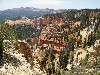
| Sept 2, 2010 |
Leave Grand Canyon to Bryce Canyon (300 mi - about 6 hours)
http://www.nps.gov/brca/index.htm - Stay at Bryce Canyon
Sunset Campground
www.recreation.gov
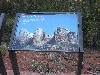
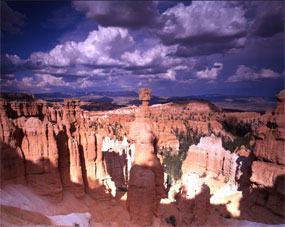 Thor's Hammer at Midday - Bryce Canyon
 |
Historic Photos (7 Photos)
Historic photos and images
|
 |
Park Pictures (9 Photos)
Photo's at various locations in the Park
|
 |
Piracy Point (Farview) (5 Photos)
View Point near Farview. Pedestrian traffic only
|
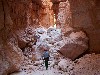 |
Wall Street (9 Photos)
Navajo Loop Trail through Wall Street on April 1 2008
|
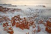 |
Winter scenes (5 Photos)
Winter Pictures of Bryce Canyon
|
Phillip Nguyen-phillipnguyen@gmail.com
Check the status of your past and current
reservations
|
#2-13407883
Confirmed |
TENT ONLY NONELECTRIC
SUNSET CAMPGROUND (UT), Bryce Canyon National Park, UT
B268, B LOOP |
Arriving: Fri Sep 03 2010
Leaving: Sat Sep 04 2010
Length of Stay: 1 (nights)
Primary Phillip Nguyen
|
Interagency Senior Pass.:
(7.50
|
Our Reservation lot # B267 Bryce
Canyon Sunset Campground under
PhillipNguyen for 1st night
Our Reservation lot # B268 Bryce
Canyon Sunset Campground under
PhillipNguyen for 2nd night
we have to wake up early for C loop first come first serve in Sat
Sept 4 morning, I will visit
http://www.recreation.gov/camping/Sunset_Campground_Ut/r/campgroundDetails.do?parkId=74088&contractCode=NRSO&chkAg=y
every day to see if any body drop
We will do hotel in Zion
Super 8 Hurricane.
65 S 700 W
Hurricane, UT 84737
United States of America
|
|
|
The reservation is confirmed by Super 8
Hurricane. Your credit card has been charged in full. If
your plans change, you must cancel or change your hotel
reservation in advance in accordance with the Expedia and hotel
cancellation policies to avoid a no-show charge. Please refer to
the cancellation and change policies listed below. |
| |
| Expedia itinerary
number: 133418180410
|
| Hotel confirmation
number: 60338816
|
|
Main contact: Phillip Nguyen
E-mail: phillipnguyen@gmail.com
|
|
| |
|
|
|
|
Traveler and cost summary
|
Expedia Special Rate |
Reserved for:
Phillip Nguyen |
Hotel: 4 adults |
Two Queen Non Smoking
| Includes:
Continental Breakfast, Free High-Speed Internet |
|
9/4: $59.99 per night
9/5: $49.99 per night
|
| Taxes &
service fees |
$7.71 per night
|
| Extra
guest charges |
$12.00
per night |
| Amount
charged for hotel reservation
|
$149.39 |
|
Room options / Additional requests
We will forward your requests to the property, but we cannot
guarantee that your requests will be honored.
2 QUEEN BEDS, Non-Smoking |
|
|
|
|
Sat Sep-4-2010 (2 nights) |
|
|
Super 8 Hurricane |
 |
|
| |
65 S 700 W
Hurricane, UT 84737
United States of America
|
|
Check in:
Sat Sep-4-2010
Check out: Mon
Sep-6-2010
|
|
|
|
Reservation questions: +1 (800) EXPEDIA
For other information contact the hotel: Tel: 1
(435) 635-0808 Fax: 1 (435) 635-0909 |
|
|
|
|
|
| Unless specified
otherwise, rates are quoted in US dollars.
|
| The price shown
above DOES NOT include any applicable hotel service
fees, charges for optional incidentals (such as minibar
snacks or telephone calls), or regulatory surcharges.
The lodging will assess these fees, charges, and
surcharges upon check-out. |
| Your room is
guaranteed for late arrival. |
| Award points and
airline mileage may not be awarded when booking an
Expedia Special Rate hotel. |
|
|
Cancel reservation? |
|
| Super 8 Hurricane, Hurricane UT |
| Dates: Sat 4-Sep-10 to Mon 6-Sep-10 |
| |
| Cancellation and changes: |
- Cancellations or changes made after 4:00 PM (Mountain
Daylight Time (US & Canada)) on 9/3/2010 are subject to a
hotel fee equal to 1 Night Room & Tax.
- Cancellations or changes made after check-in on 9/4/2010
are subject to a 100% charge.
|
Sept 4,5
Watchman Campground
is located � mile from
the South Entrance. Tent and electric campsites are available year-round
and group campsites are available by reservation from March through
October. There are 162 regular sites, 2 handicapped accessible sites and
7 group sites.
Reservations
Reservations for campsites at Watchman Campground for camping from March
6 through October 24, 2010, may be made 6 months prior to your arrival
date online at
www.recreation.gov or by calling 877-444-6777.
Beginning
March 6, 2010, part of the campground will be available on a
first-come, first-served basis.
Loops A & D:
First come, first served
(as needed) through the night of February 28, 2010; closed March 1
through the night of March 5; available by reservation March 6 through
the night of November 28, 2010.
Loops B & C: Closed through the night of March 24,
2010; available by reservation March 25 through the night of October 24,
2010.
Zion Group Sites: Four sites are available by reservation from
March 6, 2010 through March 25, 2010; all group sites available by
reservation March 26, 2010 through October 26, 2010.
There are 7 group campsites that are limited to one site per affiliated
group at a time with a seven day per stay limit. The sites can
accommodate from 9 to 40 campers. The group campsites are tent only. No
other types of camping equipment, including camper vans, pop-up campers,
or cabover campers, are allowed in the group campsites. Cost is $3.00
per person, per night.
South Campground is �
mile from the South Entrance. It is open March through October. There
are 127 campsites (including three
handicapped accessible) available first-come,
first-served. There are no hook-ups; a dump station is
available for campers. Generators are allowed from 8:00 a.m. to 10:00
a.m. and from 6:00 p.m. to 8:00 p.m. Campsites are $16.00 per night.
Owners of an Interagency Senior or Access or a Golden Age or Access Pass
receive a 50% discount on camping fees.
Lava Point Campground is
open June through October, as weather allows. Situated at 7890 feet
above sea level, it is off the Kolob Terrace Road, 25 miles (45
minutes) north of the town of Virgin. There are 6 primitive campsites
available first-come, first-served, pit toilets, and trash cans, but no
water. Vehicles longer than 19 feet are not permitted on the road to the
campground. There is no charge for camping.
During the Spring and Fall, weather conditions can change rapidly along
the Kolob Terrace Road that leads to the Lava Point Campground. Check
here for
Kolob Terrace Road Conditions.
Call 435-772-3256 for additional information on camping
Springdale is adjacent to Zion Canyon;
pay showers, a small market, firewood, laundromats, a limited
medical clinic, and restaurants are available. Springdale can be reached
from the campgrounds by car, foot, bicycle, or free shuttle (April
through October).
first night at Bryce Canyon National Park, visit ZION & BRYCE
National Park
How to use the Shuttle
http://www.nps.gov/brca/planyourvisit/shuttle.htm
Using the Bryce Canyon Shuttle is easy and convenient. If you
are not staying overnight inside the park at either the
or
North or Sunset Campground, we strongly encourage you to
leave your vehicle outside the park. Please park and board the
shuttle at the Shuttle Staging area (near Ruby's Inn) or
at Ruby's Campground. To make planning your visit even easier,
you can also take a trip on our
Shuttle eTour before you arrive.
There is no extra fee to use the shuttle system in the
developed area as indicated by the stops listed below. Paying
your $25 entrance fee to Bryce Canyon entitles you to unlimited
use of the Bryce Canyon Shuttle buses.
waive the entrance fee to not only this park
but all other National Park Service Areas and other Federal
lands that may have fees, across the entire country. If you do
not already have one of these annual passes they can be
purchased at the entrance to the park.
Bryce Canyon Shuttle 2010
The Shuttle for 2010 will begin May 7th and run through
October 11th. The shuttle will operate from 8 a.m. until 8 p.m.
each day. Route duration is about 50 minutes, not including
stops at facilities and overlooks. Check
here for a special tour. Bryce Canyon Shuttle
Stops/Route Sequence
- Shuttle Staging Area
- Ruby's Inn
- Ruby's Campground
- Bryce Canyon Visitor Center
- Sunset Campground
- Bryce Point
- Inspiration Point
- Sunset Campground
- Sunset Point
- Bryce Canyon Lodge
- Sunrise Point (General Store is nearby)
- North Campground Trailer Drop-off
- Bryce Canyon Visitor Center
- Shuttle Staging Area
Intervals between shuttle buses for the summer of 2010:
| Time |
Interval |
| 8:00 - 10:00 AM (MDT) |
30 minutes |
| 10:00 - 11:00 AM (MDT) |
15 minutes |
| 11:00 AM - 5:00 PM (MDT) |
10 minutes |
5:00 PM - 6:00 PM (MDT)
|
15 minutes
|
| 6:00 - 7:00 PM (MDT) |
30 minutes |
The last shuttle leaves Bryce
Point at 7:20 PM (MDT), exiting the park.
2010 Rainbow Point Shuttle Tour
(will do reservation when we are in Grand Canyon NP)
This season Bryce Canyon National Park will be offering a daily
guided tour to Rainbow Point, free of charge, from May to October,
twice daily at 9 am and 1 pm. Operated
by the Bryce Canyon Shuttle, this 4 � hour
roundtrip tour covers 40 miles with stops along many of the
park�s scenic viewpoints.
Reservations are required and can be made in person at the
shuttle offices at Ruby�s Inn, Ruby�s Campground, the Shuttle
Parking area building or by calling 435-834-5290 between the hours
of 7:45 AM and 7:00 PM. Reservations can be made up to 24 hours in
advance. Buses will hold up to 45 passengers and are first-come,
first-served.
Passengers can board at any of six shuttle boarding areas: Ruby's
Inn, Ruby's Campground, Shuttle Parking area (across the road from
Ruby�s Inn), Bryce Canyon Lodge, North Campground and Sunset
Campground. There will be approximately eight stops at the scenic
viewpoints within the park. Visitors are advised to dress
appropriately for the weather and bring lunch, water, etc.
This tour is ideal for backpackers wanting to be dropped off at
any of the park�s backcountry trailheads. It is important for
backpackers to adhere to the scheduled pickup times and locations
since there is only one bus for the return trip.
|


 Hotel:
